Subak irrigation system Bali explained: Subak is both a traditional irrigation network and the democratic cooperative of farmers that manages it — a system over a thousand years old that channels water from sacred mountain lakes through temples, canals, and terraces to rice paddies across Bali. UNESCO inscribed it as a World Heritage site in 2012, recognising it as one of the most intact living examples of a community-governed landscape on earth.
The subak irrigation system Bali explained properly starts not with engineering but with governance — because what makes subak remarkable is not the technical achievement of moving water down a hillside, but the social and spiritual system that has kept thousands of farmers cooperating across land boundaries, family allegiances, and competing water needs for over a millennium without a central authority to enforce it.
When you walk through the rice terraces at Jatiluwih and see a farmer adjusting a bamboo channel to divert water between paddies, you are watching the daily operation of a system that the Jatiluwih vs Tegallalang comparison describes as the reason UNESCO chose Jatiluwih specifically — not the landscape, but the living social system visible within it.
What Subak Is: Two Definitions That Both Matter
The word subak has two meanings that operate simultaneously:
Subak as infrastructure — the physical network of canals, tunnels, weirs, dams, and distribution channels that move water from rivers and mountain sources through terraced paddies. This network covers significant portions of Bali’s agricultural land and has been built and maintained by farming communities over more than a thousand years without the involvement of state engineering.
Subak as cooperative — the organisation of farmers who jointly own and manage that infrastructure. Every farmer with a paddy (sawah) connected to a subak channel is automatically a member of that subak and shares in both the rights and responsibilities of membership. Rights include an allocated water share. Responsibilities include participation in maintenance work, attendance at subak meetings, and contribution to the ceremonial calendar that governs the planting cycle.
The word itself is translated variously as “cooperation” or “rice farmer association” — both are accurate, neither is complete. A subak is more accurately described as a community institution that simultaneously manages a physical resource and maintains the social relationships required to keep managing it across generations.
How the System Works: Water from Mountain to Paddy
The physical logic of subak starts at the top of Bali’s volcanic interior. The island’s two main crater lakes — Lake Batur and Lake Bratan — function as the primary reservoirs that feed the subak network. Water flows from these lakes down rivers and streams, is captured at weirs, and is distributed into canal networks that fan across the terraced hillsides.
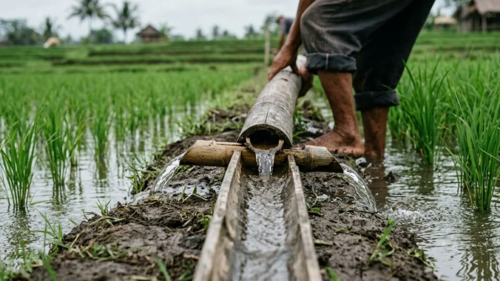
The key innovation of the subak system is its democratic water distribution mechanism. At each distribution point, water is divided among the farmers whose paddies connect to that channel using a proportional share system. The share is calculated based on the size of each farmer’s paddy — larger fields receive proportionally more water, smaller fields less — ensuring that every member of the subak receives water, and that no single farmer can monopolise the flow.
The physical mechanism for this distribution is typically a series of carved stone or bamboo diversion channels — notched to specific widths that correspond to each farmer’s allocated share. The water does not need to be measured or monitored by an overseer; the physical geometry of the channels does the allocation automatically once the system is properly set up.
At the bottom of the terrace chain, water that has flowed through all the paddies above returns to the river — typically carrying the nitrogen-rich runoff from the organic matter in the paddy soil above it, which supports the ecology of the downstream river and, ultimately, the coastal fisheries.
The Water Temples: The Spiritual Governance of the System
The most distinctive feature of the subak system — the one that separates it from purely engineering-based irrigation — is its integration with a network of water temples whose priests coordinate the planting and harvesting calendar across the whole system.
The water temple hierarchy runs from the family paddy shrine at the base, through hamlet and village temple levels, to the supreme water temple of Bali — Pura Ulun Danu Batur — which sits on the rim of the Batur caldera above Lake Batur and is considered the spiritual source of all water on the island. The priests at Pura Ulun Danu Batur do not manage water allocation directly — the local subak organisations handle day-to-day distribution. What the temple system governs is the timing of the agricultural calendar: when to plant, when to flood, when to dry out, and when to harvest.
This timing is not arbitrary. The coordinated flooding and fallowing of paddies across large areas of the subak network controls the pest and disease cycle — specifically rice pests like the brown planthopper, which proliferate when paddies are continuously planted without coordinated fallow periods. A single farmer flooding their paddy when the surrounding fields are dry creates an island of habitat for pests that then spread to neighbouring fields when they are replanted. Coordinated planting and fallow timing, governed by the temple calendar, keeps pest pressure manageable across the entire network without chemical intervention.
This was demonstrated empirically in the 1970s and 1980s, when the Indonesian government’s Green Revolution programme encouraged Balinese farmers to plant continuously rather than following the temple-coordinated calendar. Pest pressure increased dramatically, yields fell, and the government eventually reversed the policy and restored the temple-coordinated planting schedule.
The UNESCO Inscription: What Was Actually Recognised
UNESCO inscribed the Bali Cultural Landscape — including the subak system and the Jatiluwih rice terraces — on the World Heritage List on 6 July 2012. The inscription explicitly recognised the subak system not just as a technical irrigation achievement but as a living example of Tri Hita Karana — the Balinese philosophy of harmony between humans, nature, and the divine — expressed in functional agricultural form.
The inscription covers five components: Pura Ulun Danu Batur (the supreme water temple), Lake Batur (the water source), the Jatiluwih rice terraces (the most intact visible landscape), Pura Taman Ayun (a royal water temple in Mengwi), and the Pakerisan Valley (an early Balinese landscape including several ancient water temples and royal monuments).
What UNESCO recognised was not the scenery. It was the governance system — the fact that for over a thousand years, Balinese farming communities had maintained a complex water-sharing network through social and spiritual institutions rather than state authority or technological enforcement. That is the genuinely exceptional thing about subak, and it is what the rice terrace photographs on Bali tourism brochures almost never explain.
What You Are Looking at When You Walk Through Jatiluwih
The specific things visible at Jatiluwih that most visitors pass without explanation:
The bamboo diversion channels — small bamboo or stone structures in the irrigation channels that divide water flow between paddies. Each notch or gap is sized to deliver a specific proportion of water. This is the physical mechanism of the democratic water share.
The small shrines at paddy corners — every sawah has a small shrine (bedugul) at one corner where the farmer makes offerings to Dewi Sri, the rice goddess, at planting and harvest. These are not decorative — they are the household-level expression of the temple hierarchy that governs the whole system.
The channel maintenance — the physical channels require regular cleaning, repair, and adjustment. This work is the responsibility of the subak membership collectively, coordinated by the pekaseh (subak leader) who schedules communal work sessions.
The different growth stages in adjacent paddies — in a healthy subak, neighbouring paddies may be at slightly different stages of the growing cycle, reflecting the staggered planting schedule that controls pest pressure. Paddies that are all at identical stages simultaneously can indicate a disruption of the traditional coordinated calendar.
Threats to the Subak System Today
The subak system faces significant and documented pressure in 2025 and 2026 from several directions:
Urban expansion and tourism development — agricultural land converted to villas, hotels, and commercial development removes paddies from the subak network. Once removed, the hydrological relationships between remaining paddies in the network change — sometimes making the system less functional for remaining farmers.
Water scarcity — Bali’s groundwater is under significant pressure from the rapid growth of tourism infrastructure in south Bali, which pumps groundwater for hotel swimming pools and landscaping. This affects the water table that feeds the rivers and springs that supply the subak canals.
Declining agricultural income — the economics of rice farming in Bali cannot compete with the income available in tourism-adjacent employment. Young Balinese are increasingly moving to tourism service work rather than inheriting family paddies. Subak memberships are declining in some areas as paddies are sold or left fallow rather than actively farmed.
Commercial rice varieties — the high-yield commercial rice varieties promoted since the Green Revolution require more water and shorter growing cycles than traditional Balinese rice varieties, creating pressure on the subak calendar and reducing the biodiversity of the paddy ecosystem.
None of these threats are abstract. Walking through Jatiluwih and then driving back toward south Bali, the contrast between the intact subak landscape of the highlands and the villa-dense coastline is the same story told in two registers.
FAQ
What is the subak system in Bali?
Subak is both a traditional irrigation network and the cooperative of farmers who manage it. As infrastructure, it is a system of canals, weirs, and distribution channels that moves water from sacred mountain lakes through temple networks to rice paddies across Bali. As governance, it is the democratic organisation of farmers who share water rights and maintenance responsibilities according to paddy size. The system has been in continuous operation for over a thousand years and was inscribed as a UNESCO World Heritage site in 2012.
Why did UNESCO recognise the subak system?
UNESCO recognised the subak system as part of the Bali Cultural Landscape World Heritage inscription in 2012 because it is one of the most intact living examples of a community-governed landscape — a system where water allocation, agricultural timing, and land management are coordinated through social and spiritual institutions rather than state authority or technological enforcement. The inscription recognised the expression of Tri Hita Karana — Balinese harmony between humans, nature, and the divine — in functional agricultural form.
How does water distribution work in the subak system?
Water is distributed proportionally based on paddy size. At each distribution point in the canal network, physically sized diversion channels — notched to specific widths — automatically allocate water shares to each farmer’s paddy without requiring measurement or oversight. Larger paddies receive proportionally more water; smaller paddies receive less. No single farmer can take more than their allocated share without physically altering the distribution structure.
What role do water temples play in the subak system?
The water temple hierarchy — from family paddy shrines up to Pura Ulun Danu Batur at the Batur crater — coordinates the agricultural calendar across the whole subak network. Priests at each level of the hierarchy determine planting, flooding, fallow, and harvest timing for the paddies connected to their temple. This coordinated calendar controls pest and disease pressure by ensuring that paddies are flooded and fallowed in coordination rather than continuously, preventing the pest population explosions that occur when isolated wet paddies provide constant habitat.
Where is the best place to see the subak system in action?
Jatiluwih in Tabanan regency is the most accessible location where the subak system is visible at scale — 600 hectares of intact terraces with active farming and visible canal infrastructure. Sidemen in East Bali shows the system at a more intimate village scale. Both locations are best visited in the morning, when farmers are working and the channels are active. The Jatiluwih vs Tegallalang comparison explains why Jatiluwih specifically was the UNESCO choice over more-visited terrace sites.