Bali road trip east Bali: East Bali’s Karangasem regency covers roughly 840km² of coastline, rice terraces, volcanic highland, and traditional villages — most of it accessible by scooter or car on roads that range from well-maintained to narrow and steep. The region is the least tourist-dense part of Bali that is still practically accessible for independent travellers.
A bali road trip east bali circuit gives you something the rest of the island increasingly cannot: roads where you are more likely to pass a farmer on a motorbike than a tour bus, villages where your presence is noticed rather than expected, and a landscape where Mount Agung is not a distant backdrop but the thing the entire regency is organised around. This guide covers the route, the stops, what the roads are actually like, and how to structure the circuit depending on how many days you have.
East Bali’s administrative centre is Karangasem — the regency that contains Sidemen, Candidasa, Tirta Gangga, Amed, Tenganan, and the approaches to Mount Agung and Lempuyang Temple. The circuit described here runs from Ubud as a starting point and can be done as a long day trip, a two-day loop, or expanded into the five-day East Bali slow travel leg described in the Bali slow travel itinerary 2 weeks.
For the snorkeling comparison between Amed and Candidasa, the Amed Bali vs Candidasa snorkeling guide covers what to expect at the water in each area.
The Route: Ubud → Sidemen → Tirta Gangga → Amed → Candidasa → Return
Total distance: approximately 180km for the full loop back to Ubud Driving time without stops: 5–6 hours Recommended duration: 2–3 days minimum, 4–5 days for genuine slow travel
The route runs clockwise from Ubud — east through Klungkung to Sidemen, northeast to Tirta Gangga, then along the coast to Amed, south to Candidasa, and back west to Ubud via the coastal bypass. The anticlockwise version works equally well and puts Candidasa before Amed — which is logically better if you want to save Amed for last given its character as the quietest stop.
Leg 1: Ubud to Sidemen (45km — 1.5 hours)
The road from Ubud to Sidemen runs southeast through Klungkung town, then north into the Karangasem highlands. The Klungkung section is the least scenic part of the drive — a functional town road with traffic. Get through it and continue northeast toward Sidemen.
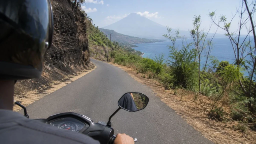
The approach to Sidemen valley begins about 10km east of Klungkung. The road narrows and begins climbing gently, with rice terraces appearing on both sides and Mount Agung emerging progressively larger ahead. By the time you reach the valley floor, Agung fills the northern horizon in a way that has no equivalent elsewhere in Bali except from specific high-altitude viewpoints.
Stop: Sidemen village and the public trekking trail (IDR 25,000 entrance). If this is a two-day or longer circuit, an overnight in Sidemen is the right call — the valley at dawn and dusk is a different landscape from the midday version. The Sidemen Valley trekking guide covers the walking options in detail.
Road condition: Good surface from Ubud to Klungkung. Narrows and undulates from Klungkung to Sidemen — manageable on any scooter or standard car.
Leg 2: Sidemen to Tirta Gangga (20km — 30 minutes)
The road north from Sidemen to Tirta Gangga passes through the highland interior of Karangasem, climbing and descending through villages and plantation land with Mount Agung visible on clear days to the northwest. The road is narrower than the Sidemen approach — two-way traffic is possible but requires attention at blind corners.
Stop: Tirta Gangga Water Palace Built in 1948 by the last king of Karangasem, Tirta Gangga is a working royal water temple complex with spring-fed pools, stepping stone channels, and carved stone fountains arranged across terraced gardens. The complex uses a continuous natural spring that has not been interrupted since construction. Entry IDR 50,000 for international visitors.
The stepping stone pools are walkable — shoes off, trousers rolled up. The upper pools are swimmable with prior arrangement through the palace office. The surrounding sawah (wet rice fields) are visible from the upper terrace and provide context for the water management logic that the palace was built to celebrate.
Arrive before 9am for the quietest experience. By 10am, day-trippers from south Bali begin arriving in organised groups.
Road condition: Narrow in sections north of Sidemen. One particular descent into a valley about 8km south of Tirta Gangga has a gradient steep enough to require engine braking on a scooter. It is not dangerous but rewards attentiveness.
Leg 3: Tirta Gangga to Amed via the Coastal Road (35km — 1 hour)
Two routes connect Tirta Gangga to Amed: the direct inland road via Amlapura (faster, less scenic), and the coastal road south from Amlapura through Ujung and along the easternmost tip of Bali (longer, significantly more interesting).
Take the coastal road.
From Amlapura, head south toward Ujung Water Palace — a second royal water complex built in the early 20th century, partially destroyed by the 1963 Agung eruption and restored. The palace sits at the southern edge of a bay with direct ocean views and is considerably less visited than Tirta Gangga. Entry IDR 50,000.
From Ujung, the road follows the coastline around the eastern tip of Bali — the road narrows to a single lane in sections, with the ocean on one side and steep hillside on the other. The driving is slow and requires full attention. The scenery is the reward: black volcanic sand beaches, fishing villages, and across the Lombok Strait, the profile of Mount Rinjani visible on clear days.
The road rejoins the main coastal highway near Seraya and continues north to Amed along the increasingly familiar tourist strip.
Stop: Amed The string of bays from Amed village through Jemeluk, Lipah, and Selang covers 10km of coastline. Jemeluk bay has the best shore-entry snorkeling. Lipah is sandier and calmer. A full afternoon in Amed — snorkeling at Jemeluk, dinner at a beachfront warung — is the right pace for this stop. Overnight in Amed strongly recommended to catch the Jemeluk morning and the east-facing sunrise.
Road condition: The coastal road south of Amlapura is the most demanding on this circuit. Single lane in sections, significant coastal erosion damage at certain points in wet season. A car with good ground clearance handles it better than a low sedan. A scooter is the most practical vehicle for this stretch.
Leg 4: Amed to Tulamben (15km — 20 minutes)
Tulamben is 15 minutes west of Amed along the north coastal road. The USAT Liberty shipwreck sits 30 metres offshore in 5–30 metres of water — the bow section at 5 metres is accessible to snorkellers without diving equipment. The wreck is most crowded between 10am and 2pm when day-trippers from south Bali arrive. Before 8am and after 3pm it is significantly quieter.
Tulamben is not worth an overnight — it is a snorkeling and diving access point, not a place with much character beyond the water. Treat it as a morning stop before continuing south.
Leg 5: Amed to Candidasa (45km — 1 hour)
The road south from Amed to Candidasa runs back along the coast through Culik, then inland and south through Amlapura toward Candidasa. The more interesting route goes back via the Seraya coastal road in reverse — or you can take the direct highway, which is faster but less scenic.
Stop: Tenganan Village 5km west of Candidasa, Tenganan is one of Bali’s Bali Aga villages — communities that predate the Hindu-Javanese cultural influence that shaped most of Bali’s contemporary culture. Tenganan maintains a distinct set of customs, agricultural practices, and textile traditions including geringsing double ikat cloth, woven only here in all of Indonesia. The village opens to visitors during daylight hours; no entrance fee but a donation register at the gate.
Updated access arrangements in 2025 require visitors to enter through the main north gate only and follow the marked path — a formal boundary not previously enforced. This was introduced after incidents involving visitors walking into restricted ceremonial areas. Follow the path and the village remains openly accessible.
Stop: Candidasa Covered in depth in the Amed Bali vs Candidasa snorkeling guide. For the road trip circuit, Candidasa works as a final East Bali overnight before the return to Ubud or south Bali — close enough to Tirta Gangga and Tenganan for morning revisits, and on the direct road west.
Leg 6: Candidasa to Ubud (65km — 2 hours)
The return runs west through Klungkung and back to Ubud via the main cross-island road. If timing allows, a stop at Goa Lawah — a bat cave temple on the coast 20 minutes west of Candidasa — adds 30 minutes and requires no entrance negotiation (the temple is roadside with a clearly marked visitor area).
The Klungkung section includes Kertha Gosa — a royal hall of justice in the centre of Klungkung town, with ceiling paintings depicting the Balinese Hindu afterlife in the style of Kamasan, the traditional painting village nearby. Entry IDR 15,000. Worth 30 minutes if you have them.
Practical Driving Notes for East Bali
Vehicle choice: A scooter gives the most flexibility and is the right call for the coastal road section and the Sidemen valley approach. A car is more comfortable for the Ubud–Klungkung–Sidemen main road section but limits options on the narrower coastal routes.
Licence: An international driving permit is legally required for both cars and scooters in Indonesia. Police checkpoints targeting unlicensed riders are common on tourist routes. Carry the permit. The Bali scams guide covers the motorbike damage claim scam — photograph all existing damage before riding.
Fuel: Fill up in Klungkung or Amlapura before heading into the more remote sections. Pertamina stations are present in both towns. Eceran fuel (bottled roadside) is available throughout East Bali but at slightly higher prices.
Google Maps reliability: Good on the main roads. Less reliable on the coastal road south of Amlapura, where the road occasionally redirects to tracks that are impassable by car. Download the offline map for Karangasem before leaving — mobile signal is intermittent on the coastal stretch.
Speed and time: East Bali road speeds average 30–40km/h on the main roads and slower on the coastal sections. Google Maps estimates consistently underestimate actual travel time by 20–30%. Plan conservatively.
Yuna had rented a scooter in Ubud and done the East Bali circuit in a single long day on her first attempt. She reached Amed at 4pm, turned around immediately because she had a morning flight from Denpasar, and drove back in the dark — the coastal road section between Ujung and Seraya in pitch darkness on an unfamiliar single-lane road. She did the circuit again on her next trip over three days, stayed overnight in Sidemen and Amed, and said the second version was a different country from the first. East Bali rewards the time you give it.
Day-by-Day Structure Options
| Duration | Structure |
|---|---|
| 1 day (long) | Ubud → Sidemen (brief stop) → Tirta Gangga → Amed → return via highway. Skip coastal road. |
| 2 days | Day 1: Ubud → Sidemen (overnight). Day 2: Tirta Gangga → coastal road → Amed → return. |
| 3 days | Day 1: Ubud → Sidemen (overnight). Day 2: Tirta Gangga → Ujung coastal road → Amed (overnight). Day 3: Tulamben → Candidasa → Tenganan → return. |
| 4–5 days | Full slow travel version — overnight in Sidemen, Amed, and Candidasa, with morning sunrise stops and unhurried driving. |
FAQ
Do I need a car or can I do East Bali by scooter? A scooter is the better choice for the full circuit. The coastal road south of Amlapura and the approach roads to Sidemen and Tirta Gangga are narrow — a scooter navigates them more easily than a car. For the Ubud–Klungkung main road, either works. If you are not comfortable on a scooter on narrow mountain roads, hire a private driver for the day rather than renting a car independently.
How long does the East Bali road trip circuit take? The minimum to see the main stops is a long single day from Ubud — approximately 12 hours including driving and brief stops at Sidemen, Tirta Gangga, and Amed. Two to three days is the realistic minimum for the circuit to feel like travel rather than transit. Four to five days allows genuine slow travel in each area.
Is the East Bali coastal road safe for scooters? The Ujung to Seraya coastal road is single lane with significant gradient and coastal erosion at certain points. It is safe in dry daylight conditions for an experienced scooter rider. Not recommended in the dark, in heavy rain, or for riders without significant scooter experience on narrow mountain roads.
What is the best time of year for an East Bali road trip? May to October — dry season, clear views of Mount Agung, passable coastal roads. Wet season (November to April) brings afternoon rain, reduced visibility, and occasional road closures on the coastal section. The circuit is possible year-round with adjusted timing — drive mornings, shelter afternoons.
Do I need a guide for East Bali? No — the circuit is navigable independently with Google Maps offline and this guide. A local guide adds value specifically at Tenganan village (cultural context) and for the Sidemen rice terrace trek (route knowledge and river crossing safety). For the driving circuit itself, no guide is needed.